DNR installs safety buoys on Cedar downtown
Published 7:01 am Wednesday, May 6, 2020
|
Getting your Trinity Audio player ready...
|
A Minnesota Department of Natural Resources crew anchored an orange buoy safety line, also known as a barrier float, on Thursday across the Cedar River on the upstream side of the Fourth Avenue Northeast bridge in downtown Austin.
The DNR crew started the morning by re-installing the barrier float used for years above Ramsey Dam before floating down the river to remove tree-related hazards for paddlers in the wooded stretch north of Interstate 90. Once at Austin Mill Pond, the crew installed the new barrier float above the downtown dam where there is a small clearing on the east riverbank.
Afterward, the crew floated the rest of the Cedar River State Water Trail to the Minnesota-Iowa border, removing other hazards and reporting “excellent” conditions for paddling on the river.
With the barrier float, paddlers and boaters will see the orange warning for not going further downstream due to the dam. The barrier also will offer a line anchored to each side of the river for getting safely to the shoreline.
In August 2019, a DNR crew surveyed the shorelines above the downtown dam for installing a barrier float for the 2020 season. The DNR had been waiting for the major property redevelopment work to conclude at the former downtown power plant site along the river’s west side. That site now hosts the new YMCA at Austin Community Recreation Center and an earthen flood berm with a paved pedestrian trail along the river.
Cedar River Watershed District staff have been working with the DNR to add the safety measure downtown. CRWD also continues to work with the DNR and the City of Austin to explore possible funding, including state bonding, to create a safe portage around the downtown dam.
“As more people – locals and tourists – seem to be paddling the Cedar River State Water Trail, this is a welcomed addition by the DNR to enhance the safety of water recreation here,” said Tim Ruzek, CRWD’s outreach coordinator.
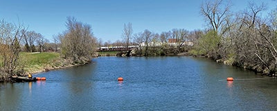
In an effort to enhance water-recreation safety, a Minnesota Department of Natural Resources crew installed a barrier float Thursday on the Cedar River State Water Trail above the downtown Austin dam. Photo provided
DNR has used a similar barrier float above Ramsey Dam, where it maintains a public motorized boat access across the river from The Old Mill Restaurant on Austin’s northern edge. This access is used for boaters and paddlers to head upstream into the Cedar River’s Ramsey Mill Pond – the biggest waterbody in Mower County – that borders the DNR’s 395-acre Ramsey Mill Pond Wildlife Management Area (WMA).
Since 2012, the DNR has maintained and promoted the Cedar River State Water Trail that flows south from the Mower County Road 2 bridge near the village of Lansing to the Minnesota-Iowa border. CRWD, with the support of State Sen. Dan Sparks and State Rep. Jeanne Poppe, gained legislative approval in 2011 for the Cedar to be named a DNR state water trail.
With that designation, DNR crews float the Cedar River State Water Trail several times a year to maintain DNR signage and access points as well as remove hazards to paddlers and boaters, such as fallen trees. In 2019, the DNR did substantial work to address numerous trees blocking portions of the river, mainly between Austin’s two dams on the Cedar.
The DNR removes hazardous parts of downed trees but not the entire tree. Woody debris helps protect against soil erosion along a riverbank and provides habitat for fish, turtles and wildlife.
People can report hazards on the river to CRWD or directly to the DNR by calling (800) 657-3929 or submitting an online report at www.dnr.state.mn.us/watertrails/conditions.html.
Other safety tips, trail maps, real-time river level data and other paddling information for the state water trails are online at www.dnr.state.mn.us/watertrails. Minnesota has 35 state water trails that offer more than 4,500 miles of paddling and are within one hour from where most Minnesotans live.
The DNR offers river-level data online for the Cedar River State Water Trail through gauges at County Road 2 near Lansing and south of Austin at County Road 28 in Austin Township. Color-coded ratings are offered for the levels, with “medium” being the most-ideal for paddling.
Other paddling safety tips from the DNR include:
• Scan ahead for hazards, such as overhanging trees, rocks, low bridges or rapids.
• If a river section appears too challenging, don’t be afraid to portage around it. This is much better than paddling in rapids or quick currents that you are not used to navigating. When in doubt, get out and scout!
• Riffles in the water mean rocks are dangerously close to the surface. Follow the smooth water shaped like a “V” pointing downstream.