Snow moving in this weekend brings wintery mix
Published 6:17 pm Thursday, March 7, 2019
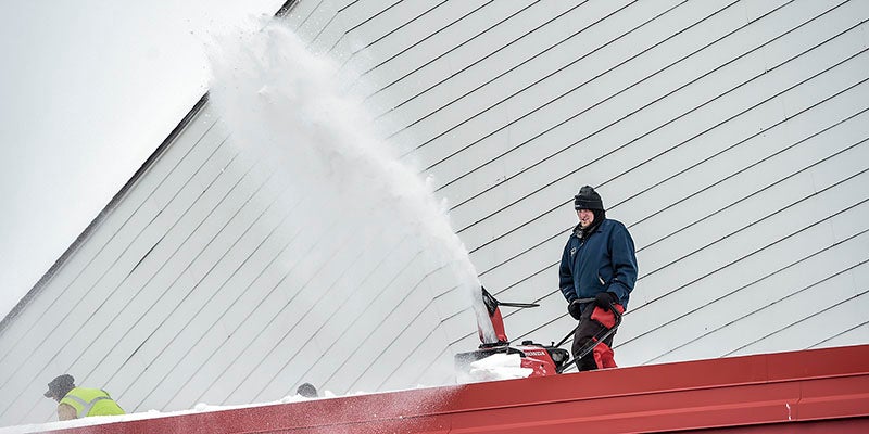
- Aaron Heimer kicks snow off a roof at Riverside Arena Thursday morning using a snowblower. The area, as well as a larger chunk of Minnesota, is hunkering down as another storm that moves into the area Saturday. Eric Johnson/pohotodesk@austindailyherald.com
Most people didn’t think there could possibly be any more snow this winter, but Mother Nature again proves to be unpredictable.
Another winter storm has taken aim at southeast Minnesota for the weekend, which looks to bring in another wintry mix with an anticipated 4 to 8 inches of snow anticipated to fall over the region beginning early Saturday morning, with the bulk predicted to fall during the afternoon and evening hours, according to the National Weather Service in La Crosse.
The storm will continue through the night, moving northeast early Sunday morning. There’s potential for a period of freezing precipitation before the main snow moves in, and possibly as it exits. If freezing precipitation happens, then a light glaze of ice could be possible on the roads.
Another factor during the storm will be wind during the late hours of Saturday and into Sunday morning, causing drifting of fallen snow.
Travel will be affected, and drivers are cautioned to be prepared for slippery to hazardous driving conditions, especially for afternoon and evening hours. Snow is expected to be heavy in nature.
“The way things look at the moment, there is going to be a heavier winter storm to the north and west of the Austin region,” said Todd Shea, NWS meteorologist. “We don’t envision a full-blown blizzard like a couple weekends ago, but we do expect storm impacts on traveling, and may cause some problems as the weekend goes along.”
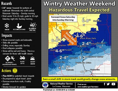
Current layout for this weekend’s winter storm. Photo courtesy of the National Weather Service
Most of the recent storms have traveled from the west and southwest parts of the country, drawing up more moisture and warmer air. Shea said while next week is warmer in temperatures, another possible storm may be arriving on Tuesday going into Wednesday.
However, that particular trek may change, Shea noted.
“We have to keep an eye on it,” he said. “Again, it’s a warmer-type weather system. We’re kind of watching it closely, and there’s potential for a storm, but it’s hard to work that out as of now. Some information we have says it might come through as more rain than snow, and may stay off in the west and back in the Dakotas and northern Minnesota. At this point, we’re anticipating more of an additional rain threat. We’ll keep an eye on it, and the storm track may change.”
With the characteristics of the storm to bring about heavier, wetter snow, Shea suggested that it may be possible that roofs already covered in a significant amount of snow may face further strain this weekend, as well as potential flooding issues.
“Flooding risk is starting to increase, and we need to keep an eye on that,” he said. “Another thing is to have people be more prepared, especially on rooftops. With the additional snow threats, given another added load, there could be more roof collapses and more related issues we may not see in the winter.”
Perilous travel conditions
High winds expected with this system could result in dangerous road conditions, and Mower County Sheriff Steve Sandvik and Mower County Emergency Management Coordinator Amy Lammey are urging residents to avoid travelling.
“We expect many roads to be impassable,” Sandvik said. “Some people may not think it’s that much snow, but with those winds it won’t take long to fill in snow drifts and cover the roads.”
“Everyone should pre-plan to stay off the roads,” Lammey said.
During the Feb. 23-24 storm, emergency personnel rescued approximately 350 people in 120 stranded vehicles, Sandvik said. Many had to spend Saturday night in their vehicles as white out conditions overnight made finding the roads extremely difficult. Rescue crews also came across multiple abandoned vehicles on the roads.
Sandvik said if travel cannot be avoided, do not follow a GPS if the interstate is closed. Conditions on county and township roads deteriorate faster than on state roads, and many motorists rescued in the previous storm were trying to follow GPS routes on rural roads.
Sandvik also said that during storm conditions, snowplows are only used for emergency purposes, such as rescue operations and clearing routes for ambulances. He urged residents not to assume the roads are safe just because a snowplow came through.
Road conditions can be seen at 511mn.org.
Clearing roofs
Under Minnesota State Code, residential roofs in the southern part of the state are constructed to an anticipated design depth of 35 pounds per square foot. Snow weighs between seven and 20 pounds per cubic foot, meaning a range of 0.58 pounds per square foot for every inch of snow depth for light, powdery snow to 1.67 pounds per square foot for every inch of heavy wet snow.
When clearing your roof of snow and ice, the Minnesota Department of Public Safety has the following tips:
• Think about safety first. If possible, do not attempt to clear the roof alone.
• When possible, use long-handled roof rakes or poles designed for roof snow removal.
• If you must use a ladder, make sure the base is securely anchored. Ask someone to hold the ladder while you climb.
• Plan ahead so you know where the snow you clear will fall and what it will land on.
• Do not touch electrical wires.
• If the job is too big for you, ask neighbors for help or hire a service.
Loss of heat/power
Keeping the gas meter clear of snow and ice can prevent a loss of heat to your home. Gas meters need air intake to operate properly. Snow and ice on gas meters should be removed by hand or with a brush or broom, not with sharp objects, hot water, salt or ice melting chemicals.
In the event of heat loss, the DPS advises the following:
• Use safe alternative heat sources such as a fireplace, a small, well-vented wood or coal stove, or a propane space heater. Follow the manufacturer’s instructions and never substitute one type of fuel for another.
• Dress in layers of lightweight clothing and wear a cap.
• Eat well-balanced meals and stay well hydrated.
• Close off rooms you do not need.
In order to avoid carbon monoxide poisoning by an alternative heat source:
• Ensure adequate ventilation.
• Do not operate generators indoors or near ventilation.
• Do not use charcoal or gas grills indoors.
• Do not use your gas oven or dryer to heat your home.
If you home loses power during the storm, the DPS suggests these steps:
• Notify the utility company as soon as possible and determine anticipated repair time.
• Turn off or unplug lights and appliances to prevent a circuit overload when the power returns. Leave one light on to let you know the power has been restored.
• Keep refrigerator and freezer doors closed as much as possible to avoid food spoilage.
• Avoid and report downed power lines or areas where ice, trees or objects are laying on the lines.
• If someone in your home is on life-support or otherwise electricity-dependent due to a disability, immediately notify Mower County Emergency Management at 507-437-9533
Michael Stoll and Hannah Yang contributed to this story.


