CRWD finishes water quality projects south of Austin; Crews complete 3 berms along Cedar River as part of 25-project initiative
Published 7:33 am Monday, November 20, 2017
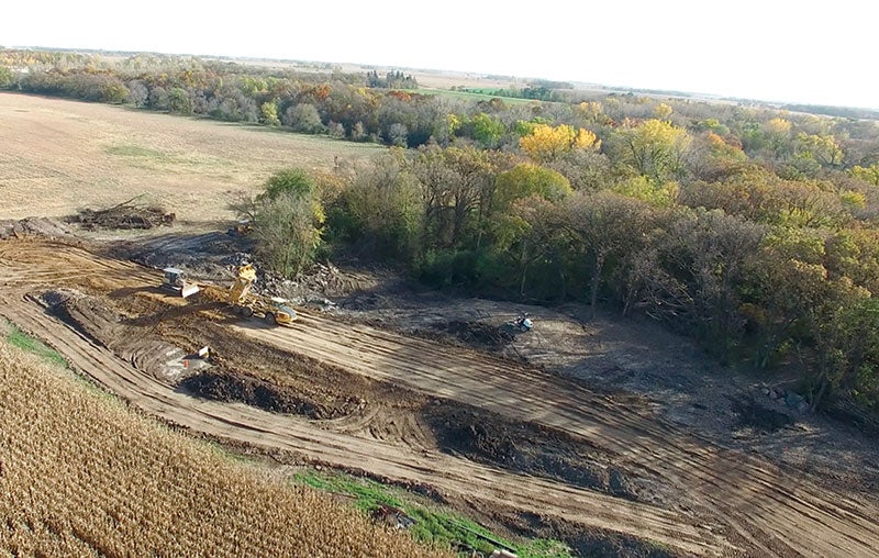
- A crew builds a ravine-stabilization berm this fall on Dwane Hull’s property in Austin Township near the Cedar River. Photo provided
By Tim Ruzek
Water Plan & Outreach Coordinator, Cedar River Watershed District
Rain falling on more than 500 acres of mostly cropland south of Austin now will be slowed and treated by three earthen berms before reaching the nearby Cedar River State Water Trail.
Crews on Thursday planted grass seed and made other final touches to the berms constructed this fall in Austin Township as part of the Cedar River Watershed District’s five-year, $8.4 million Capital Improvement Project (CIP) to build 25 structures on farm land to improve water quality and reduce flooding.
CRWD worked with landowners Dwane Hull and Jeffrey Pederson to bring the nearly $200,000 ravine-stabilization project to reality and, in doing so, address erosion issues related to stormwater drainage on nearly one square mile of land.
“We’ve had outstanding landowners to work with on these projects,” said Cody Fox, CRWD’s project manager overseeing the CIP initiative that now has four completed projects. “These berms were a high priority because they offered opportunities to catch a large amount of sediment just before reaching the river.”
These berms with the Hull-Pederson projects are expected to protect the Cedar River from receiving about 78 tons per year of sediment and 156 pounds of phosphorus, which, if in the river, could create nearly 40 tons of algae.
Fitzgerald Excavating of Goodhue, Minn., constructed all three berms.
CRWD’s CIP initiative consists of the district’s top 25 prioritized projects that range in size, complexity and location. They generally relate to detaining stormwater in storage structures built in upland or headwater farmland areas but also include ravine stabilization and flood-risk reduction.
Most of the 25 CIP projects are planned for upstream of Austin, with a majority currently targeted in the Dobbins Creek subwatershed, which is highly prone to flash flooding. Dobbins’ two branches meet at Austin’s Jay C. Hormel Nature Center before it becomes East Side Lake due to a dam and flows into the Cedar River at Austin’s Driesner Park.
Strategic construction of upland storage structures helps CRWD slow water flows while keeping more soil and nutrients from entering local waterways. This also reduces flood damage to buildings, infrastructure and farm fields.
CIP projects aim to achieve 40 to 70 percent flow reductions on most individual sites as well as an 8 percent overall reduction at the confluence of Dobbins Creek and the Cedar River in southeast Austin. CRWD’s long-term plan calls for a 20 percent reduction in flood flows.
In spring 2018, CRWD plans to start construction on its largest CIP project – known as Dobbins 1 – in the headwaters of Dobbins Creek’s north branch in Red Rock and Dexter townships. When completed, the nearly $1.5 million project will consist of two water-retention structures or earthen dams that, during large rain events, temporarily will hold stormwater covering more than 50 acres, which is larger than the 40-acre East Side Lake.
Once completed, Dobbins 1 is expected to reduce stormwater flows in its localized area by 80 percent, keeping about 134 tons of sediment and 218 pounds of phosphorus per year out of Dobbins, Fox said.
This spring, CRWD completed its first CIP project – about $60,000 – along Dobbins Creek’s north branch at the Anderson-Oelkers site in Red Rock Township southeast of Brownsdale. That site is downstream from the Dobbins 1 project location.
Earlier this year, state Sen. Dan Sparks and Rep. Jeanne Poppe, both of Austin, helped secure $1.7 million in state funding from a bonding bill to help CRWD match a $3.2 million grant awarded in 2015 by The Hormel Foundation for CIP projects through a request by the local Vision 2020 Waterways Committee. The Hormel Foundation awarded CRWD the grant to use as leverage in obtaining other funding sources for CIP projects.
CRWD now has access to matching funds of up to $3.8 million from state grants and a local project levy. CRWD will keep pursuing funding for the overall initiative and work to avoid needing to use all of the CIP’s levy potential.
This is the CRWD’s 10th anniversary year of forming in 2007 to address concerns with area flooding and water quality. The district’s boundaries cover about 435 square miles, including portions of Mower, Dodge, Freeborn and Steele counties.