River-level data is now online for the Cedar River
Published 10:37 am Tuesday, July 26, 2016
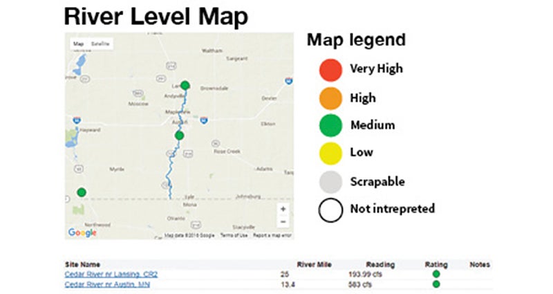
After about 2-3 inches of rain fell in the Austin area Saturday, the Cedar River State Water Trail was at “medium” level as of Tuesday morning.
Thanks to new information launched just a few weeks ago by the state of Minnesota, canoeists and kayakers can now go online to see that the storm’s effects on the Cedar River was nothing of concern for paddlers. In fact, the increased flow in the river actually created ideal paddling conditions designated online with the color green for a “medium” river-level range.
Earlier this month, the Minnesota Department of Natural Resources began offering river-level data online for the Cedar River State Water Trail as part an overall revamping of the DNR’s paddling web tool for all 35 state water trails.
Designated in 2011 by the Minnesota Legislature as a state water trail, the Cedar River never has had river level information available online like other state water trails until now. The DNR site offers daily information for the Cedar River based on stream gages near Lansing at the Mower County Road 2 bridge and south of Austin at Mower County Road 28.
“This is a great, user-friendly tool that we are excited is finally available for the Cedar River,” said Tim Ruzek, the CRWD outreach coordinator who helped lead CRWD’s efforts to designate the river as a state water trail, in a press release. “The growing number of paddlers on the Cedar will find it very useful along with others who fish the river and our numerous volunteers who adopt stretches for litter cleanups.”
Brian Pirmantgen, who last summer opened the waterway’s only outfitting business, Cedar River Canoe & Kayak Rental Service, with his wife Dorothy, used to make almost daily trips to the river to check levels, especially after rain events. He is appreciating the new online data for the Cedar River.
“I love it. This saves me time and money spent on gas,” Pirmantgen said in the release.
DNR uses five colors to interpret a river’s levels or flow, ranging from “scrapable,” which is when the watercraft will likely scrape river bottom, low, medium, high and very high, which is the danger threshold cautioning people of all paddling skill levels to stay off a river.
In Minnesota, the Cedar River typically is a moderately flowing waterway with no major rapids but it does have two dams that are recreational hazards. This summer, the DNR plans to work with the city of Austin to install an orange safety buoy cable across the Cedar River above the Fourth Avenue Northeast dam, with a middle buoy stating: “Danger Dam.” This buoy system will be similar to one that has been on the river for years above the Ramsey Dam on Austin’s north edge.
Access ramps for canoe and kayak portaging above and below the Fourth Avenue dam still are in the works but need funding after not receiving state bonding funds in this year’s legislative session, said Ruzek, who also co-chairs the Austin Vision 2020 Waterways Committee working with the city on the project.
As for the river-level reporting site, DNR says paddlers now can view nearly 120 real-time river level gage interpretations with almost all of these gages updated via satellite on an hourly basis. In providing river-safety information to the public, the DNR wants to increase user satisfaction and help people plan river trips. All interpretations should be considered subject to change as continual refinements are made from staff and public input.
Under the revamping, DNR increased the number of river gages offered online from 110 to 124 and added interpretations for 42 of 50 gages that didn’t have that. DNR added 37 new gages to the website — including for the newer Cedar River and Shell Rock River state water trails — and removed numerous obsolete gages as well as cleaned up information.
A prominent mechanism for public feedback also will be added at some point to the DNR’s river level reporting webpage. DNR also aims to continue improving interpretations and locate new sites for interpretations along state water trails.
As a state water trail, the Cedar River has a webpage through the DNR with various information on it and a downloadable map that also is printed as a foldable brochure by the DNR and available at the CRWD office in Austin. The river also gets DNR assistance with navigational hazards, particularly fallen trees causing safety issues. A DNR crew floats the river several times a year to check for and remove hazards as well as look at access sites and their signage.
Paddlers are encouraged to contact the CRWD or DNR about hazards on the Cedar River, and DNR will aim to check on the matter within a week of receiving a report. These types of reports have increased greatly this season, showing that the number of people paddling the Cedar River is growing.
Key State Water Trail links
•Cedar River State Water Trail website: www.dnr.state.mn.us/watertrails/cedarriver
•River-level conditions for state water trails: www.dnr.state.mn.us/river_levels
•DNR’s river-level interpretations for paddling: http://files.dnr.state.mn.us/destinations/water_trails/river_level_definitions.pdf
•List of all state water trails: www.dnr.state.mn.us/watertrails/az