Two-berm project set for 2023 in Dobbins
Published 5:04 pm Friday, March 31, 2023
|
Getting your Trinity Audio player ready...
|
CRWD to build upland storage for stormwater in creek’s south branch
Two berms spanning a quarter-mile in length each are part of a nearly $1 million project in the headwaters of Dobbins Creek’s south branch that will play a big role in reducing floods and improving water quality.
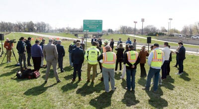
The Cedar River Watershed District will soon seek bids for construction this summer of the earthen berms six miles east of Austin in Red Rock Township on cropland owned by farmer Al Akkerman. It is north of Interstate 90 and east of Mower County Road 19.
About 60 percent of the project’s funding will come from the state’s Clean Water Fund, with the rest mostly covered by a grant from The Hormel Foundation in Austin. A small portion will be funded by a federal Environmental Protection Agency grant.
Combined, the dams will provide temporary storage for stormwater running off 467 acres of mostly cropland.
“We definitely will make good progress toward our goals when these berms are in place,” said Cody Fox, CRWD’s administrator and project manager. “We’re grateful for Mr. Akkerman’s willingness to work with us on the plans.”
CRWD’s Board of Managers approved the project’s plans at its March 22 meeting. This project is a continuation of CRWD’s Capital Improvement Plan (CIP) started in 2016 to build structures that capture large amounts of stormwater and slowly release it. This decreases the amount and speed of stormwater flow, reducing the potential for major streambank erosion downstream.
With upland storage, much of the sediment, excess nutrients and other pollutants in stormwater settles to the bottom of the basin behind the berms rather than continue into Dobbins Creek, East Side Lake and the Cedar River.
With the Akkerman site, the berms will be the first structures built under CRWD’s second CIP phase. A north berm will be 1,500 feet in length with a peak height of 12 feet; the south berm will be 1,250 feet long and 10 feet high.
CRWD’s first CIP phase had a goal of an 8% peak flow reduction, which was achieved with a $3.2 million grant from The Hormel Foundation and another $3.4 million in state and local funding that built 14 projects, including 11 upland-storage structures in the Dobbins watershed.
In 2020, CRWD built its most-recent CIP project also in the headwaters of Dobbins’ south branch. That $1.2 million project created a nearly 2,000-foot-long berm in Dexter Township, with a 21-foot peak height.
When the Akkerman berms are finished, CRWD’s upland-storage projects in the Dobbins watershed will treat stormwater coming from 3,967 acres of mostly cropland, which is nearly 6.2 square miles. The projects will also have the combined ability to temporarily hold up to 410 million gallons of stormwater when levels reach each berm’s spillway.
For perspective, Austin’s largest water tower — on the west side of town — holds 1 million gallons of water.
With the two berms, CRWD’s overall system of CIP upland structures will provide a 14% reduction in stormwater flows during what’s known as a 100-year flood event, which has a 1% chance of happening every year, Fox said.
“It doesn’t sound like a lot but that reduction really can make a big difference,” Fox said.
A few years ago, CRWD’s CIP projects achieved a 10 percent reduction that equals a nearly 1-foot drop in Dobbins’ peak flows at Austin’s Jay C. Hormel Nature Center when the area experiences a 10-year rain event or roughly 4 inches of rain. With such a rain storm, some rural roads can become overtopped with flooding, particularly in the flashy Dobbins watershed, Fox said.
CRWD officials also are optimistic that any bonding bill passed this spring by the state Legislature will include a significant amount of funding for future CIP projects in the Dobbins watershed.
East Side Lake, a stretch of Dobbins Creek downstream from the nature center that was created by a dam and a manmade lake basin, benefits from CIP projects keeping less sediment or earthen material from fields, roads and streambanks from flowing into it.
“As we keep doing these projects in the headwaters,” Fox said, “we hope to reach a point where the state will determine that Dobbins Creek can be delisted for being impaired for sediment. That also will mean the creek has much better water quality.”