Confirmed December tornadoes in Minnesota now at least 16
Published 9:27 am Wednesday, December 22, 2021
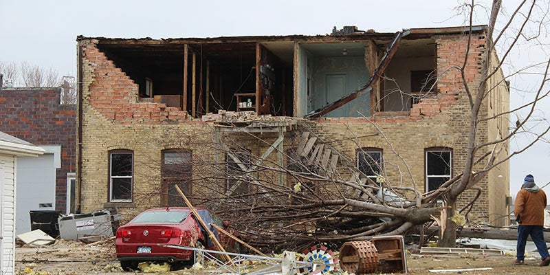
- The back wall of the building in downtown Hartland that hosts the post office was ripped off Wednesday night during severe weather. Sarah Stultz/Albert Lea Tribune
|
Getting your Trinity Audio player ready...
|
By Andrew Krueger
The number of tornadoes confirmed to have touched down in southern Minnesota on Dec. 15 is now at least 16.
The number has increased in recent days as National Weather Service crews have completed additional surveys in the wake of the severe storms — including one more tornado touchdown confirmed Tuesday morning. Prior to this year, there had never been a confirmed tornado in Minnesota in the month of December.
The strongest of the tornadoes was the one that caused major damage to buildings in Hartland, Minn., northwest of Albert Lea. It was an EF-2, with estimated peak wind speeds of 115 mph.
The tornado touched down about a mile southwest of the city and tracked northeast. It had a peak width of about 55 yards and was on the ground for just over 2 miles, over the span of about 3 minutes.
There were no reports of injuries or deaths from the tornadoes, though a man was struck and killed by a falling tree as severe storms moved through the Rochester area that night.
In addition to the Hartland tornado, the other Dec. 15 tornadoes confirmed by the National Weather Service offices in the Twin Cities and La Crosse include:
- An EF-1 tornado that touched down northeast of Walters and tracked about 3.6 miles to just southwest of Alden in Freeborn County, just before 7 p.m. Barring another, earlier confirmed tornado, this would be the very first one reported in Minnesota in the month of December. It had a maximum width of 90 yards and peak winds estimated at 105 mph, damaging trees and utility poles before lifting just south of Interstate 90.
- A few minutes later, another EF-1 tornado touched down east of Alden in Freeborn County, tracking for about 1.6 miles with peak winds of 100 mph. It had a peak width of about 40 yards and caused damage to trees and a farm outbuilding, the Weather Service reported.
- An EF-1 tornado touched down southwest of the community of London in Freeborn County just before 7:15 p.m., with a path of about 4.5 miles. It destroyed a large machine shed.
- An EF-0 tornado touched down about 3 miles south of Hayward in Freeborn County at about 7:15 p.m., staying on the ground for about 4 miles and partially tearing the roofs off several buildings.
- An EF-1 tornado touched down north of Myrtle in Freeborn County just after 7:15 p.m., destroying several outbuildings as it stayed on the ground for about 4 miles.
- An EF-1 tornado with winds estimated at up to 110 mph tracked for more than 3 miles in northeast Mower County, near Racine, just after 7:30 p.m. It had a maximum estimated width of 85 yards and tore the roof off a home, as well as causing damage to trees and outbuildings.
- An EF-0 tornado touched down just before 7:45 p.m. in Sumner Township in northwestern Fillmore County, with winds estimated at up to 85 mph. It caused damage to trees and farm buildings as it tracked for more than 4.6 miles with a peak width of 80 yards.
- An EF-0 tornado touched down in Preston in Fillmore County just before 7:45 p.m. It was on the ground for about a half-mile with winds up to 80 mph and a maximum width of 40 yards. It caused damage to vehicles, trees and sheds.
- An EF-1 tornado touched down northeast of Preston at 7:45 p.m. and tracked for about 1.6 miles, with winds up to 105 mph and a maximum width estimated at 75 yards. It caused damage to trees and farm buildings.
- An EF-1 tornado with estimated peak winds of 93 mph touched down just after 8 p.m. about 3 miles southeast of Plainview in Wabasha County. It was on the ground for about 4.5 miles, damaging trees and farm buildings as it tracked northeast.
- Also just after 8 p.m., an EF-0 tornado touched down southeast of Lewiston in Winona County. It was on the ground for about 0.6 miles with a peak width of 40 yards and maximum winds estimated at 85 mph. It caused damage to trees, a garage and other outbuildings along County Road 23.
- A brief EF-1 tornado tracked south and east of the community of Arendahl in Fillmore County just after 8 p.m. It was on the ground for just over a mile, damaging trees with peak winds estimated at 95 mph and a peak width estimated at 250 yards.
- An EF-1 tornado tracked for just over 2 miles in northeast Fillmore County, south of Rushford, just after 8 p.m. It had estimated peak winds of 90 mph and a peak width of 75 yards, and caused damage to trees and farm buildings.
- An EF-1 tornado with estimated peak winds of 90 mph touched down in northwestern Houston County just after 8 p.m., tracking for more than 7 miles northwest of the city of Houston. It had an estimated peak width of 250 yards and caused damage to trees and farm buildings.
- An EF-1 tornado touched down in Winona County, southeast of the city of Winona, just after 8:15 p.m. It was on the ground for about 2.6 miles, passing over the community of Homer and ending on an island in the Mississippi River. The tornado had estimated peak winds of 100 mph and an estimated peak width of 40 yards, and caused damage to trees and outbuildings.
The Weather Service also reported at least five tornadoes touched down in northeast Iowa on Wednesday night and at least five in western Wisconsin.