Mower SWCD finishes first project in major study; More to come as part of Root River Field to Stream Partnership
Published 10:38 am Wednesday, January 18, 2017
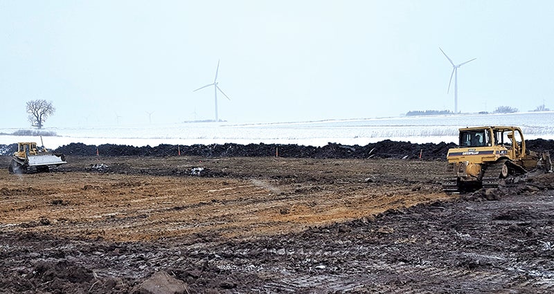
- Crews install two water-and-sediment control basins in December at a Clayton Township farm in Mower County for the Root River Field to Stream Partnership. Photo provided.
With snow on the ground, crews late last year finished the first of many water-quality projects expected in the headwaters of Root River’s south branch in eastern Mower County, according to the Mower Soil & Water Conservation District.
The MSWCD led construction of a two-basin terrace system to control water and sediment on a Clayton Township farm field as part of the second phase of the Root River Field to Stream Partnership led by the Minnesota Department of Agriculture.
Work involved building two berms — each berm at least the length of two football fields — to hold and filter storm water running off about 20 acres of crop land.
“This project is a great example of things to come from the Field to Stream Program,” said Aaron Gamm, Mower SWCD district technician. “We’re excited to be working closely with landowners in the Root River watershed on conservation projects that are tied to extensive monitoring to determine their effectiveness.”
With the basins, sediment and phosphorus losses are expected to be reduced by more than 50 percent from the 20-acre field, said Kevin Kuehner, project lead with the Minnesota Department of Agriculture (MDA).
Six other basins could be built in the next two years in the 2,800-acre watershed study area in Mower County along with thousands of feet of grass waterways planned for the 2017 planting season.
Started in 2009, Field to Stream uses innovative equipment and technology to monitor sediment and nutrient runoff from farm fields and to study streams receiving storm water. Information collected during the project’s initial six-year phase provided farmers with baseline data to better understand the effects of their existing conservation practices. Farmers learned when soil and nutrient losses were happening and how much was leaving their field to enter nearby waterways. Monitoring continues at these sites as the second phase begins.
Mower SWCD monitors and maintains three water-sampling stations for the project in Mower County’s Bennington Township, north of LeRoy. The stations sample surface and tile runoff water from the field edge along with water in a ditch at the outlet of the headwaters study area. Sampling has continued into this winter.
“Even though there’s snow covering frozen ground, the drainage tiles are still flowing due to wet conditions this fall,” said James Fett, Mower SWCD’s watershed technician who leads sampling efforts at the Mower County sites.
Best management practices, known as BMPS, have been used widely by farmers for decades, Kuehner said. Field to Stream is studying if their use in a targeted area could meet the growing demand for better water quality in the agricultural landscape.
“By installing additional practices for surface runoff and nitrate-nitrogen leaching, the partnership aims to monitor water-quality change at the outlet of the headwaters watershed,” Kuehner said. “This science-based effort holds the potential of helping answer key questions and tell a positive story about how the collective efforts of farmers can protect and improve water quality.”
Phase two of the program will involve conservation planning and installing more field projects. Work during the first phase included farm walkovers in the study watershed areas to evaluate the extent and condition of existing on-farm conservation efforts as well as identify where additional practices could reduce filed sediment and nutrient losses.
Every farmer agreed to participate in the voluntary walk-over in Mower County’s study area, and almost all the farmers plan to address high runoff risk areas over the next several years, Kuehner said.
Mower County’s study area is in till uplands region in the Root River watershed’s western portion. Flat terrain with poorly drained soils dominates the landscape, where mainly corn and soybeans are grown by farmers.
The 1 million acre-Root River Watershed — nearly the size of the state of Delaware — was chosen for the project due to its diversity of land type. The Root River starts as a drainage ditch in Mower County and eventually empties into the Mississippi River near Hokah, Minn. For more on the Root River Field to Stream Partnership, go online to: www.mda.state.mn.us/cwf/rrpartnership.