Study: Cover crops, less tillage key to water goals
Published 7:56 am Monday, October 23, 2017
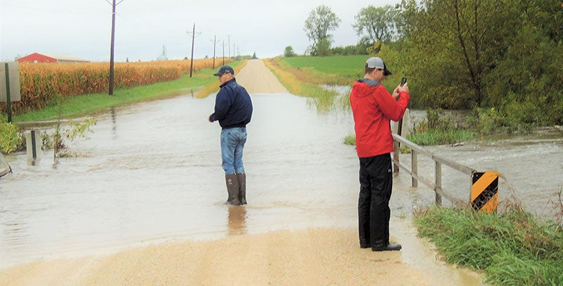
- Cedar River Watershed District staff checks flooding September 2016 of the North Branch of Dobbins Creek at the 250th Street bridge in Red Rock Township, south of Brownsdale. Photo provided
Realistic soil health strategy could reduce storm flows by 30 percent in Dobbins Creek
Known for flash flooding, the Dobbins Creek subwatershed could see significant water quality progress with more cover crops and less tillage on its farm fields, according to a new study.
Stormwater flow likely would be reduced by 30 percent in the Dobbins Creek subwatershed that enters the Cedar River in Austin with best-management practices implemented in critical areas along with 30 percent of its farmland getting year-round vegetative cover, including crops, cover crops and post-harvesting residue, the study says.
This week, Jim Solstad, a retired state modeling hydrologist, presented the Cedar River Watershed District staff with the results of his study that included work on the Dobbins subwatershed.

A map of the Dobbins Creek Watershed. Photos provided
With the findings, local staff now can see a realistic scenario in which agricultural economics and water-resource improvements can go together, CRWD administrator Justin Hanson said.
“This shows that a combination of conservation and water-retention projects along with cover crops and reduced tillage is the recipe for success in our watershed,” Hanson said. “That’s not only going to be effective for water quality but it also will have a dramatic effect on water quantity.”
Modeling in the study – funded by a state Clean Water Legacy grant – analyzed land management practices, particularly for how much each practice could offer for stormwater flow reduction. Much of the sediment runoff in Dobbins is caused by high flows.
Ideally, best management practices on Dobbins’ ag land would include water-and-sediment-control basins, grassed waterways, and vegetative buffers. The study found these practices are effective individually but don’t achieve enough collectively to reach CRWD’s goals, such as reducing stormwater flows by 20 percent in the entire watershed district. That’s why it recommends incorporating cover crops and other soil-health practices, such as strip tillage, on at least 30 percent of Dobbins’ farm fields.
Cover crops and soil health practices – such as minimal or no tillage – can help reduce soil erosion and stormwater runoff, increase stormwater infiltration in fields, and keep excess nutrients from leaving the soil, among other benefits. Cover cropping involves planting a second, unharvested crop in coordination with regular cash crops, such as corn and soybeans.

Cover crops established in fall 2016 in a Mower County corn field.
The study considered current land conditions along with practices being done by landowners in Dobbins while only looking at practices that would be realistic and a good fit for the local watershed.
“We didn’t want to include a bunch of practices that a landowner most likely wouldn’t want to do on their land and would skew the data,” Hanson said. “We wanted something realistic.”
Dobbins Creek – listed by the state as “impaired” for aquatic life and turbidity (cloudiness) – has north and south branches converging at Austin’s Jay C. Hormel Nature Center. A large dam on it forms East Side Lake before it flows into the Cedar River.
Overall, the Dobbins subwatershed totals more than 25,700 acres. About 71 percent of those acres are used for intensively-farmed row crop ag land, with most being prime farmland that continuously produces high-grain yields.
Dobbins has a terrain that, along with current land management practices, does not offer much for natural water storage and leads to its tendency to flash flood, Hanson said. Local staff want to connect with landowners and ag producers interested in cover crops and other soil-health practices, he added, as CRWD expects this year to have funding in place for cost-share assistance.
CRWD is highly focused on Dobbins, especially through its nearly $8.4 million, five-year capital improvement project initiative launched in 2016 to improve water quality by constructing 25 water-retention structures on farm fields, mostly in upland or headwater areas. A large majority of the projects are planned for the Dobbins subwatershed.
In 2014, CRWD also launched a $2.1 million project mainly funded by the state to partner with the University of Minnesota in implementing projects in the Dobbins subwatershed while also conducting extensive testing for water quality and aquatic life. A $1.5 million state grant enabled CRWD to implement a full suite of projects that fit nearly any landscape.
Under that project, CRWD has taken a “treatment train approach” that has involved addressing upland field erosion; holding water and sediment before entering Dobbins; treating nutrients between the fields and creek; stabilizing eroding streambanks; and restoring critical in-channel features that support aquatic life.
Last month, CRWD-Mower Soil & Water Conservation District also announced a three-year research project involving several dozen plots on Mower County farms – about half in the Cedar River Watershed – to provide better soil health data to support ag operations and practices benefiting the environment. Funded by a $98,000 grant from The Hormel Foundation, the study will look at the benefits of incorporating cover crops and other soil-health practices into farm operations.