Cedar River 1W1P project approved by state; Project to create water- management plan based on watershed boundaries
Published 10:24 am Monday, August 29, 2016
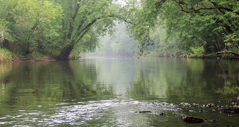
- A picture of the Cedar River State Water Trail this August at the County Road 28 bridge south of Austin. -- Photo provided
State officials have approved funding for a One Watershed, One Plan project focused on protecting and improving the Cedar River along with its tributaries.
Last Thursday, members of the Minnesota Board of Water & Soil Resources (BWSR) approved up to $1.7 million overall for seven watersheds, including the Cedar River Watershed, to conduct the state’s next round of One Watershed, One Plan (1W1P) projects. The Cedar River 1W1P requested $192,500 for its process that will begin this fall and run for two years.
Mower Soil & Water Conservation District worked with neighboring agencies to submit the 1W1P application after receiving formal support from county and Soil & Water Conservation District boards in Dodge, Freeborn, Mower and Steele counties as well as the board members of the Cedar River Watershed District and Turtle Creek Watershed District.
Staff from each of those local-government units will be part of a planning work group for Cedar River 1W1P. One board member from each of the organizations also will serve on a policy committee that oversees and guides the project.
Officials from various state agencies and other stakeholder groups will provide feedback through an advisory committee.
 “We are grateful for the state’s support and excited to start the 1W1P process with our area partners in the Cedar River Watershed,” said Tim Ruzek, water planner for Mower SWCD, in a press release. “This plan will help us better focus on priority areas and seek funding for projects that address water quality, flooding and other resource concerns.”
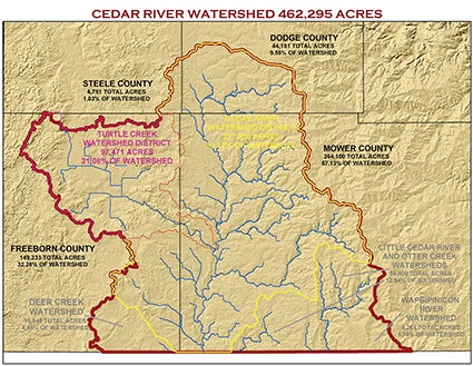
Overall, the Cedar River 1W1P boundaries will cover 462,295 acres. Most of the land — about 57 percent — is in Mower County, with 32 percent in Freeborn; 10 percent in Dodge; and 1 percent in Steele (includes Blooming Prairie).
Cedar River Watershed District’s political boundaries are within the 1W1P area along with the Turtle Creek Watershed District’s area and the watersheds for the Little Cedar River, Otter Creek, Wapsipinicon River and Deer Creek (southeast Freeborn County).
Under 1W1P, the state aims to create plans based on watershed boundaries rather than smaller, political boundaries. This will ensure that the most significant threats to a watershed’s water resources are addressed with practices providing the greatest environmental benefits. The plan will not add a new layer of government.
It intends to provide a framework for consistency and cooperation on a watershed basis, allowing local governments to work together to implement projects with the highest return on investment for improving issues related to water quality and water quantity. The project also aims to detail how a watershed’s partners will implement the plan and work cooperatively.
BWSR has led the statewide 1W1P program that aims to reduce the more than 200 water plans statewide to less than 100. Watershed-based plans have the potential to allow for streamlined funding and administration to maximize efficiency, minimize redundancy and prevent duplication of efforts both on the local and state levels.
Local water plans in the Cedar River Watershed either are overdue for updates or coming up for renewal.
Mower SWCD staff — which also is contracted annually to perform the duties of the Cedar River and Turtle Creek watershed districts — has been involved with the Root River 1W1P pilot project for the past two years along with Dodge County and Dodge SWCD staff. Much of eastern Mower County lies in the Root River 1W1P’s area, which covers more than 1.3 million acres in parts of six counties.
In September, Root River 1W1P will host two public hearings in the area on its draft water management plan as it heads into the project’s final stages. Fillmore SWCD has led the Root River 1W1P process.