Fierce storms top a day of stifling heat, humidity
Published 10:18 am Monday, July 13, 2015
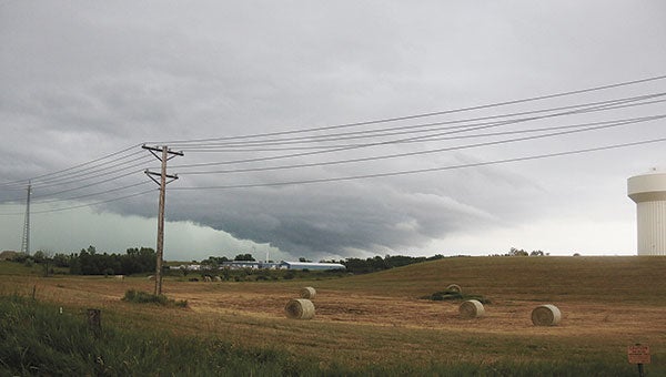
A view of the dark clouds near the Fergus Falls water tower from Weyrens Road. Marie Noplos/Daily Journal
By Paul Walsh
Star Tribune (Minneapolis)
Sunrise Monday brought a better view of the damage from the previous night’s stormy weather that stretched from western Minnesota, through the Brainerd area and into the Twin Cities.
Trees were down and thousands of people were without electricity in the Brainerd lakes area, and a barn was destroyed about 6 miles southwest of Staples, according to the National Weather Service (NWS). Thunderstorms brought down power lines in several parts of Todd County, the weather service added.
The Gull Lake Dam and Recreation Site near Brainerd was evacuated of campers, and ordered closed immediately and indefinitely, according to the U.S. Army Corps of Engineers.
“Hundreds of trees are down” in and around the campground, the corps said in a statement. Campers are being ordered out so crews can begin tree removal. The camp’s boat ramp is also closed, the corps added.
There also were reports of damage at Brainerd International Raceway, in particular a section of metal grandstand.
In the Twin Cities area, Lakeville was among locations reporting house fires due to lightning strikes, one of those a duplex on 170th Street.
The heavy rain pushed dirt and other debris onto the far right lane of southbound Interstate 35E at Hwy. 36, bogging down traffic during the morning commute into downtown St. Paul. A crew from the Minnesota Department of Transportation is on cleanup duty.
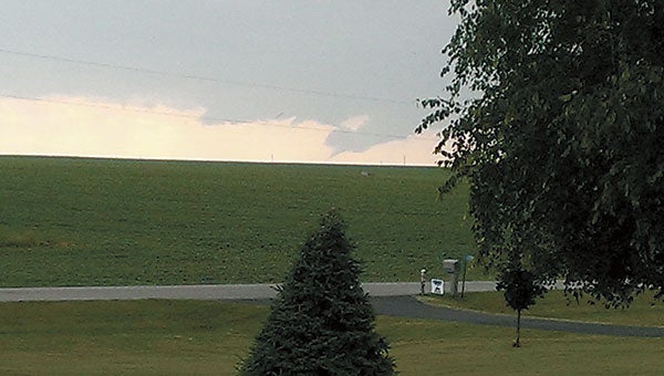
Gary Johnson took this photo of a funnel cloud that appears to touch down Sunday evening near his home on Ten Mile Lake, about 14 miles south of Fergus Falls. Photo provided
Several inches of rain fell in many parts of the lower half of the state, including 3.5 inches in Brandon in west-central Minnesota and 3.2 inches in Maple Plain in western Hennepin County, the weather service reported.
In Wright County, strong winds toppled three large trees and tore through a corn crop southwest of Howard Lake, the NWS said.
The storms gained momentum shortly before 6 p.m. Sunday in far western Minnesota, spawning funnel clouds near Fergus Falls. Tornado warnings were issued, and wind gusts soon reached 80 miles per hour in Douglas and Morrison counties, the weather service said.
NWS meteorologist Jennifer Ritterling said the agency detected four unconfirmed tornadoes in Grant, Wilkin and Otter Tail counties.
Monday appears to be a much calmer, albeit still muggy, day for the Twin Cities and surrounding communities. The weather service is forecasting a high of 88 degrees, with a slight chance of storms by late afternoon. Otherwise, skies should be mostly sunny.
The rest of the week’s forecast envisions highs in the lower 80s, with storms falling into the maybe-maybe not category starting Wednesday.
Distributed by Tribune Content Agency, LLC.
Severe storm threat
There is a chance of thunderstorms across the area this afternoon and evening, with higher chances along and east of the Mississippi River. Should storms develop, some could be severe.
The greatest threat is south and east of La Crosse, Wisconsin later this afternoon and early evening.
Austin forecast for today into tomorrow
Today: Isolated showers and thunderstorms before noon, then a slight chance of showers and thunderstorms after 3 p.m. Mostly sunny, high near 88 degrees.
Tonight: 10 percent chance of showers and thunderstorms before 7 p.m. Partly cloudy, with a low around 67 degrees.
•Information from National Weather Service