New trail segment unveiled; One-mile stretch will connect Austin to Shooting Star
Published 11:15 am Friday, August 8, 2014
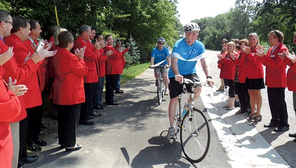
Vision 2020’s Steve Kime, right, and Laura Helle bike through a ribbon to break ground on Austin’s news segment of trail Thursday. — Photo provided
Austin has added another bike/walking trail connection to make the trail system more user-friendly.
“We have a great, great trail system now, but it’s going to be even better,” Vision 2020 Bike/Walk Committee Co-Chairman Steven Kime said.
Kime and Vision 2020 Director of Vision Creation Laura Helle rode their bikes through the ceremonial ribbon cutting on Thursday afternoon to reveal the new trail segment in northeast Austin. The Vision 2020 Bike/Walk committee, the city of Austin and the Austin Area Chamber of Commerce ambassadors hosted the unveiling.
The new trail segment is about a mile long and was completed this summer. Part of the city of Austin’s 15-mile trail system, the segment is located west of the Jay C. Hormel Nature Center on 21st Street Northeast, and runs outside of the south border of the nature center to 28th Street Northeast near the Austin County Club.
This segment will serve as the connection of the Austin trail system to the Shooting Star Trail from Rose Creek, which is scheduled to be built in 2015.
“It’s very important because it really becomes the connecting point to the Shooting Star Trail,” Kime said.
The city of Austin will also construct a trail segment linking the Mill Pond area to the tunnel under Interstate 90 near the Hormel Institute in 2014.
The Vision 2020 Bike/Walk committee has also improved trail navigation. In cooperation with the city of Austin and Mower County’s Statewide Health Improvement Program (SHIP), 13 directional signs have been installed at key navigation points to clarify trail routes. Vision 2020 volunteer Dan Urlick designed and installed a series of scannable QR codes that allow trail users to see a map of the trail system with a “you-are-here” arrow.
These amenities will make the trail system easier and safer for residents and visitors to use. A complete map of the city of Austin trail system can be found at www.ci.austin.mn.us/Engineering/PDF/biketrail.pdf.
“I think that it kind of raises our trail system up a little,” Kime said. “It’s something that other cities don’t have and other cities are jealous of.”