Austin dodges the heaviest of morning rain
Published 11:16 am Wednesday, June 18, 2014
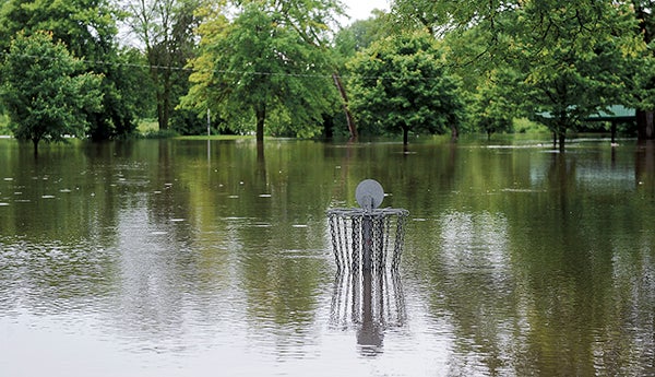
The disc golf course at Driesner Park will be out of commission for quite some time as waters from the Cedar River rose in the night after another round of showers blanketed the area. — Eric Johnson/photodesk@austindailyherald.com
The Austin area may have dodged a bullet this morning.
The storms originally expected to hit the area last night stalled out until early this morning, bringing heavy rains and a severe thunderstorm warning around 4 a.m.
The Austin area received between half an inch to just under an inch of rain, missing the heaviest rainfall totals of 2 to 4 inches in Wisconsin, according to Tom Stangeland, hydrometeorological technician with the National Weather Service in La Crosse. But with the 3-plus inches of rain Monday night, there’s nowhere for the flood waters to go.
“We have to continue to watch this because now we’re with high levels and saturated ground,” Stangeland said.
A flood warning was in effect this morning for Austin’s Cedar River, Turtle Creek and Dobbins Creek. The waterways were expected to peak a little above flood levels this morning before the waters started receding. However, more rain is almost certainly coming to the region tonight and tomorrow, but the weather service isn’t certain where the weather will hit.
“Within the region, it will rain again tonight,” Stangeland said.
The storms could bring high winds, heavy rains and isolated tornadoes late tonight and tomorrow. A high of 83 is forecasted in Austin both days.
With the potential for more rain, Stangeland urged people living in the flood plain to closely monitor the situation.